
Camping

Hiking

Horseback Riding

Seasonal Hunting
Ross Prairie State Forest is a 3,542-acre tract of public conservation land that was acquired in 1995 through the Conservation and Recreation Lands (CARL) program with funding from the Preservation 2000 Act. The State Forest is managed by the Florida Forest Service under a multiple-use concept. The Florida Forest Service works to protect, conserve and enhance the forest's unique resources so they will be available for future generations. Ross Prairie State Forest is located in Marion County approximately 10 miles southwest of Ocala. Access is off State Road 200.
The main area of the wetland, known as Ross Prairie, lies to the north of the forest on properties managed by the Florida Department of Environmental Protection’s Office of Greenways and Trails. This wetland is a freshwater basin marsh characterized by open areas of wetland grasses surrounded by live oak hammocks. These prairies will contain water in the wet season and become completely dry in the dry season. The 150-acre portion of the prairie located in the forest is made up of marshes varying in size from 1 acre to more than 50 acres. Various species of wading birds are commonly seen here. In addition to the depression marshes, the forest’s diverse ecological communities include sandhill, scrubby flatwoods, mesic hammock, mesic flatwoods and scrub.
Florida’s landscape evolved with the natural occurrence of frequent forest fires. One of the many benefits of fire is that it shapes the landscape and plays a role in determining the plants and animals associated with various forest communities. Without regularly occurring fire, forest communities would have a change in species composition; unique plants and animals maintained by fire would be lost. State Forest managers use prescribed burning to mimic the natural occurrence of fire that is so important to maintaining the forest's unique plant and animal diversity.
Recreational opportunities in the forest include hiking, bird-watching, horseback riding, camping and hunting. The main access point is from the Ross Prairie Trailhead located along State Road 200 a mile south of County Road 484. This trailhead, managed by the Florida Department of Environmental Protection’s Office of Greenways and Trails, has vehicle and equestrian parking, a full-service campground, restrooms and picnic pavilions.
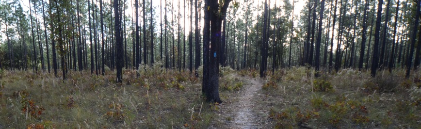
The Holly Hammock Trail is a marked 2.3-mile hiking trail that meanders through mesic hammocks and sandhills and along depression marshes. This trail provides the visitor with opportunities for nature study, wildlife viewing and photography. For primitive camping information, visit ReserveAmerica.
For equestrian users, Ross Prairie State Forest has 15 miles of designated trails along existing service roads and fire lines. This is in addition to the numerous miles of equestrian trails throughout the Marjorie Harris Carr Cross Florida Greenway property that borders the forest on the north. While riding our trails, please note that proof of current negative Coggins test is required for all horses in all Florida State Forests.
Hikers and horseback riders, see our and Trailwalker and Trailtrotter programs.
Ross Prairie State Forest is also incorporated into the Wildlife Management Area system, which is administered by the Florida Fish and Wildlife Conservation Commission (FWC). The Florida Forest Service cooperates with the FWC in the setting of wildlife and hunting regulations in the forest. Hunters are subject to the specific hunting rules established for Ross Prairie State Forest as well as those that apply on private lands.
In keeping with its mission to protect and manage Florida's forest resources, the Florida Forest Service has developed rules that apply to all State Forest visitors. Find out more about State Forest fees and rules.
Day use is from sunrise to sunset.
Indian Lake Forestry Station
6675 NE 40 Avenue Road
Ocala, FL 34479
(352) 732-1779
Email Ross Prairie State Forest
Passes are no longer available at the State Forest office. To purchase a pass or make a reservation, visit ReserveAmerica or call 1-877-879-3859.
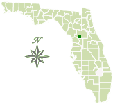
Total Acreage: 3,542
Counties: Marion
Smart device mapping is possible and encouraged in the State Forests. Before visiting a forest, search for “PDF Maps” in the app store to find an app that works for you and download our State Forest map, which is georeferenced.
 310.6 kB
]
310.6 kB
]
Contact:
Amelia McKnight
Waccasassa Forestry Center
Amelia.McKnight@FDACS.gov