Biking

Camping

Fishing

Hiking

Horseback Riding

Paddling
Seminole State Forest is one of many public properties in the scenic Wekiva River Basin. Day-use entrance fees, annual passes and camping reservations must be paid through ReserveAmerica or by calling 1-877-879-3859. A State Forest Use Permit can be obtained for day-use vehicle access by calling (352) 589-1762.
Since 1990, Seminole State Forest has been managed by the Florida Forest Service, to protect and maintain the forest's native biological diversity while integrating public use of the resources. Multiple-use management promotes recreation, timber, wildlife, endangered species, environmental education and many other values that benefit Florida's citizens and visitors.
The distinctive character of Seminole State Forest is its ecological diversity, which includes almost all of the naturally occurring vegetative communities found in Central Florida. There are more than 17 different natural communities, each with unique plants, animals and physical characteristics. A few examples are flatwoods, scrub, hydric hammock and sandhill.
The scrub provides important habitat for many rare and threatened species, such as the Florida black bear and scrub-jay.
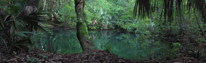
The Wekiva River, along with Black Water Creek, has been nationally designated as the Wekiva Wild and Scenic River System. Black Water Creek flows through the State Forest, and the Wekiva River forms a portion of the forest's eastern boundary. Numerous small streams and springs run through Seminole State Forest before joining Black Water Creek. Eighteen named springs exist on the property.
There are eight primitive campsites on the forest that have fire rings and picnic tables. Three of these campsites are group campsites, two are hike-to only, and one is a hike-to or paddle-to site. For reservations, visit ReserveAmerica or call 1-877-879-3859. Three primitive camp zones are located along the Florida National Scenic Trail and are available for trail users. One additional primitive camp zone is located at the adjacent Lower Wekiva River Preserve State Park and is accessible from the Lower Wekiva Loop Trail.
Single and multiple-use trails provide vast areas for exploration of the varied natural communities and provide connections to approximately 20 miles of multiple-use trails located on the adjacent Lower Wekiva River State Preserve. On Seminole State Forest, over 32 miles of hiking trails have been developed and are maintained by the Florida Trail Association. Seventeen miles of the Florida National Scenic Trail crosses multiple parcels of Seminole State Forest, stretching from State Road 46 north to the Ocala National Forest. Seminole State Forest contains two hiking trails that are included in the Florida Forest Service's Trailwalker Hiking Program. The Lower Wekiva Loop Trail is 10.4 miles round trip from the Bear Pond Trailhead, and the North Sulphur Island Loop Trail is 8.5 miles round trip from the Cassia Trailhead. A series of spur trails provide connections to trailheads and parking areas and the adjacent trails on the Lower Wekiva River State Preserve. Hiking is also permitted on all open roads, unless otherwise posted.
Twenty-six miles of horse trails are available for day use. Spur trails provide connections between parking areas, three-loop trails and the adjacent trails on the Lower Wekiva River State Preserve. Loop trails include the 7.2-mile River Creek Loop, the 7.4-mile Sulphur Island Loop, and the 4.2-mile Paola Loop. The River Creek and Sulphur Island Loop trails are included in the Florida Forest Service's Trailtrotter Program. Horse trailer parking and access to the trails are provided at the trailheads. Proof of a current negative Coggins test is required for all horses. Horseback riding is restricted to trails designated for that use.
Off-road bicycles are permitted on over 25 miles of designated open roads (named roads). Access to the designated open roads is provided by walk-through openings located at the trailheads. The open roads system contains areas of packed and sandy roads. To check the current road condition, contact the Seminole State Forest Visitor Center. This woods road system provides a 7-mile connection between the two trailheads and a series of loop and spurs roads. Access is also provided to the adjacent trails on the Lower Wekiva River State Preserve by multiple-use trails.
Canoeing on Black Water Creek provides a glimpse of an undisturbed blackwater stream. Hand-launched watercraft are permitted to access Black Water Creek, north of the concrete bridge on Sand Road. Petroleum fuel motors are prohibited. A picnic table is provided for day use at the canoe launch.
Portions of Seminole State Forest are managed as a Wildlife Management Area (WMA) through the Florida Fish and Wildlife Conservation Commission (FWC).
| Season | Seminole Forest WMA | Lake Tracy Unit, Seminole Forest WMA |
|---|---|---|
| Archery | Sept. 26–29, 2026 Sept. 30–Oct.4, 2026 | Sept. 24–27, 2026 Oct. 1–4, 2026 |
| General Gun - Mobility Impaired | Oct. 23–25, 2026 | N/A |
| Muzzleloading Gun | Oct. 30–Nov. 1, 2026 | Oct. 29–Nov. 1, 2026 |
| General Gun | Dec. 5–8, 2026 Dec. 9–13, 2026 | Nov. 12–15, 2026 Nov. 19–22, 2026 |
| Wild Hog-Still Season | N/A | Dec. 11–13, 2026 Dec. 18–20, 2026 Jan. 15–17, 2027 |
| Small Game | Jan. 16–17, 2027 Jan. 23–24, 2027 Jan. 30–31, 2027 | Jan. 8–10, 2027 Jan. 22–24, 2027 Jan. 29–31, 2027 Feb. 5–7, 2027 Feb. 12–14, 2027 |
| Spring Turkey | Mar. 20–24, 2027 Mar. 27–31, 2027 | Youth Turkey: Mar. 12–15, 2027 Mar. 20–22, 2027 Mar. 26–28, 2027 |
Day use is from sunrise to sunset.
Seminole State Forest Visitor Center
28500 State Road 44
Eustis, FL 32736
(352) 589-1762
Shanin.Cox@fdacs.gov
Passes are no longer available at the State Forest office. To purchase a pass or make a reservation, visit ReserveAmerica or call 1-877-879-3859.
Two trailheads provide primary access for recreational use. The Bear Pond Trailhead is located north of State Road 46, approximately 5 miles west of Interstate 4. Cassia Trailhead is located south of Brantley Branch Road, 0.1 miles east of State Road 44 in Cassia. The trailheads provide parking areas, entrance gates and access to the recreational trails.
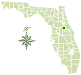
Total Acreage: 30,459
Counties: Lake
Smart device mapping is possible and encouraged in the State Forests. Before visiting a forest, search for “PDF Maps” in the app store to find an app that works for you and download our State Forest map, which is georeferenced.
 917.1 kB
]
1.7 MB
]
917.1 kB
]
1.7 MB
]
Resources:
792.8 kB
]
2.1 MB
]
1.3 MB
]
74.3 MB
]
The Florida National Scenic Trail passes through the forest.
This State Forest is part of the Great Florida Birding and Wildlife Trail.
1.5 MB
]
Contact:
Shanin Cox
Shanin.Cox@FDACS.gov