

Hiking

Biking

Fishing
Carl Duval Moore State Forest and Park are located in the central portion of Putnam County, east of Interlachen, Florida. In 1993, the property was deeded by the Carl Duval Moore estate to the state of Florida to be used for public purposes as a forest. The forest is managed by the Florida Forest Service under the multiple-use management concept to restore, protect and manage ecosystem functions while allowing compatible public uses.
Carl Duval Moore State Forest is one of the smallest State Forests (336 acres) but still maintains a variety of ecosystems, including sandhill, mesic flatwoods, wet flatwoods and flatwoods lake.
Sandhill communities occur on the tops and slopes of well-drained, rolling hills. These nutrient-poor sites consist of scattered longleaf pines growing over a dense, grassy understory. Sandhills are maintained by fire and have a very pyrogenic understory. Under natural conditions, sandhills burn approximately every two to four years, and this plant community depends on these frequent fires.
Mesic flatwoods are an open-canopy forest of widely spaced pine trees with little or no midstory and a dense ground cover of herbs and shrubs. Flatwoods plants are often flooded in the wet season but struggle to obtain enough moisture in the dry season.
Up and Down Lake is considered a flatwoods lake. Its water is mostly runoff from immediate surrounding uplands. The classic flatwoods lake is surrounded by a dense ring of saw palmetto and other shrubs. Around most of its shore, Up and Down Lake has a narrow fringe of this type of vegetation that grades into either mesic flatwoods or sandhill through several feet of elevation gain. In the northeast corner, Up and Down Lake grades into a baygall community, which has a shallower elevation change and more organic soils.
Wildlife commonly seen in the forest include bald eagles, otters, wood ducks, turkeys and gopher tortoises. Some of the common plants found in the forest are wild persimmon, winged sumac, wire grass and prickly pear cactus.
Recreational opportunities include hiking, wildlife viewing and photography. The main trailhead and parking area for the forest are along West Street, approximately four-tenths of a mile north of State Road 20. The Up and Down Lake Trail is 1.2 miles in length and has interpretive tree identification signs along the route. The trail also provides visitors with two areas from which to view the forest's most notable natural feature, Up and Down Lake. The first viewing area is an observation platform at the end of a short boardwalk four-tenths of a mile from the trailhead. The second area overlooks the 23-acre lake near the north bank. After moving away from the lake edge, the trail leads hikers through sandhills and mesic flatwoods plant communities.
In keeping with its mission to protect and manage Florida's forest resources, the Florida Forest Service has developed rules that apply to all State Forest visitors. Find out more about State Forest fees and rules.
Day use is from sunrise to sunset.
Carl Duval Moore State Forest and Park/Etoniah Creek State Forest
390 Holloway Road
Florahome, FL 32140-2537
(386) 329-2552
(386) 329-2554 Fax
Email Carl Duval Moore State Forest and Park
Passes are no longer available at the State Forest office. To purchase a pass or make a reservation, visit ReserveAmerica or call 1-877-879-3859.
Carl Duval Moore State Forest and Park is located in Putnam County, 45 minutes east of Gainesville between Interlachen and Hollister.
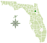
Total Acreage: 336
Counties: Putnam
Smart device mapping is possible and encouraged in the State Forests. Before visiting a forest, search for “PDF Maps” in the app store to find an app that works for you and download our State Forest map, which is georeferenced.
 391.4 kB
]
970.6 kB
]
967.1 kB
]
391.4 kB
]
970.6 kB
]
967.1 kB
]
Contact:
Amelia McKnight
Waccasassa Forestry Center
Amelia.McKnight@FDACS.gov
